
Inside of the Grand Canyon- 4 Day Guide to Havasupai Tribal Lands & Havasu Falls
- christinegrindle
- Jul 27, 2025
- 16 min read
My first guest-writer post, how exciting! Unfortunately, I was not able to attend this trip, and still wanted to be able to share such an amazing experience with everyone. My mom, uncle, aunt, and aunt's friend spent 4 days exploring the Grand Canyon in a very unique way. This post was guest-written by my aunt, and in this post, you'll read about their experience hiking, learn about the Tribal Lands in the Grand Canyon, and find some tips and tricks for your own hike to Havasu Falls. This is certainly a bucket list experience for me one day!
Disclaimer: This post contains affiliate links. If you click on one of the links and make a purchase, I may earn a small commission at no additional cost to you. I only recommend products and services that I genuinely use and trust.

Table of Contents:

Trip Overview & Background
This past April I had the amazing opportunity to hike down into the Grand Canyon with my sister, brother and friend, to Havasu Falls. Havasu Falls is a 100-foot waterfall located on the lands of the Havasupai Tribe, 10 miles deep within the West Rim of the Grand Canyon. It is only accessible by hiking, helicopter or horse, and a permit is required. Located in Havasu Canyon of the Grand Canyon, the reservation sits along side the Havasu Creek, a tributary of the Colorado River known for its turquoise color water. In addition to Havasu Falls, there are 5 other waterfalls in the area worth visiting. This trip has been on my list for about 7 years. A permit is needed to enter the reservation and I was able to secure my first permit for the summer of 2020. As Covid shut down many Native American lands across the United States, all permits were canceled that year. The next time my name was selected for a permit I was given the dates October 1-4, 2024, so we made plans and were training to go. A flash flood hit the area August 22 of that year, and again, the area was closed to all visitors. The tribe did a wonderful job cleaning up the area and redoing the trails to the falls. We were given the option of keeping our original date or choosing any date for the 2025 season. The trail was scheduled to reopen September 30, so we were hesitant to continue our October plans in case of any unforeseen delays. After another disappointment, we chose April 26-30, 2025. We felt this was the right decision for our group and after being there agreed we couldn't have picked a better week to hike. The weather was perfect- Sunny each day and temperatures around 70-75 degrees. Nights were a cool 50 and great for tent sleeping.

Permit Information & Pricing
Permits are good for 3 nights and 4 days, which is exactly the right amount of time, in my opinion, to spend exploring the area. Permits are available on www.havasupaireservations.com. An account needs to be set up, then a reservation can be made. Make sure to read the Rules and Policies page as there is a lot of helpful information found there. Each permit can include 12 people, and each day 100 permits are awarded. We chose to camp in the campground but there is a lodge in the village that you can get reservations for as well. The cost for a campground reservation in 2025 is $455 per person, and $2277 for the lodge per person. We also put in for a pack animal to carry our backpacks down to and up from the campground. Cost for this is $400 total and the animal can carry 4 bags at 32 pounds each. Presale reservations go on sale from mid December to early January. Check the website for exact dates for 2026. General Reservations open February 1 and usually sell out that day. A list of permit cancellations is updated every morning throughout the year at 8:00am Arizona time. This is an excellent and easy way to get a permit, especially if you are flexible with your dates.
Preparing for the Hike
We all trained about 3 months for the hikes. I followed a modified version of the Couch to Rim to Rim training guide found here https://www.3000milestoacure.com/wp-content/uploads/2016/06/12-Week-Training-Plan-Grand-Canyon-Hike.pdf . We all found training on stairs to be very helpful, as well as a lot of squats and lunges. We are all avid hikers so we were focusing more on strength and endurance. In our opinion, the hikes were not that hard and we saw a lot of non hikers doing just fine. We were prepared for the hikes to be more strenuous and were pleasantly surprised when they weren't.
The day before we left for Arizona, I downloaded all of the trails from AllTrails the day before as I learned the only place that has cell service is the village. We used these maps daily to find the waterfalls and as reassurance that we were on the right trails at all times. I also used it to track my miles and we came out with hiking just over 50 miles in 4 days. Below is a day by day breakdown of what worked for us on this trip and how we feel we made the most of our time within the canyon walls.
Pre-Day 1: Arrival in Peach Springs
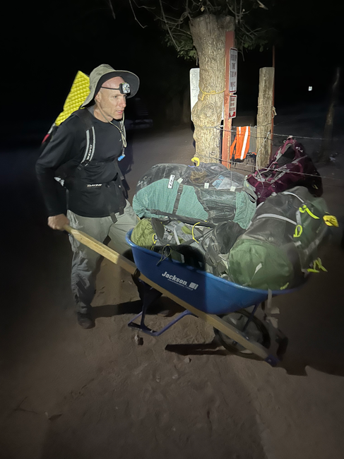
We flew into Las Vegas airport and arrived in Peach Springs Arizona at 3:00pm. We chose to stay here because it is the closest town to the trailhead, about 60 miles away and 1 hour 15 minutes drive time. It is a very small town but has gas, food, lodging and water. We had reservations at the Grand Canyon Caverns Inn. We reserved the Bunk House, which was basically a trailer home but was perfect for the 4 of us. We chose to stay here because permits for the hike need to be picked up at the Grand Canyon Caverns Inn, regardless where you are coming from. Permits can be picked up before 5:00 pm the night before your permit dates, or after 9:00 am the morning of the first date of your permit. We ate dinner at the restaurant on site, showered, and packed our backpacks for the next day.
Day 1: Hike to the Campground & Havasu Falls
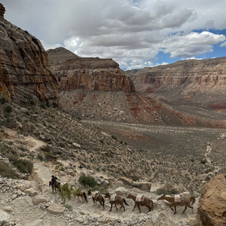
We arrived at the Hualapai Hilltop Trailhead at 6am. We were fortunate to get parking spots right by the entrance. Parking fills up quickly and it is possible you will have to park along the road up to 1 mile from the trailhead. We left our backpacks for the pack animals and began our long descent into the canyon with our tents, food and water in our daypacks. We all wore layers of clothing and trail runners. The trail begins with 2 miles of switchbacks and then levels off a bit and becomes a slight decline. When we started the temperature was 28 degrees but the sun was out by 8:00 am and it reached 65 by then. Miles 2-4 were pretty flat and there were areas where the trail split, giving you the option to hike on the crushed rocks or a more sandy trail. Since it was a chilly morning we usually opted for the trail in the sun. It was around mile 4 that we passed our first mule train heading up the trail. These animals move fast and from what I heard don't necessarily get out of your way. We were quick to jump to the side of the trail whenever we heard them coming. Miles 4-6 have a little more up and down hiking. We took our time and looked around all directions to appreciate how far we were already into the canyon. It is beautiful to be surrounded by the tall canyon walls and you really get a feel for how isolated you are. At around mile 6.5 there is a sign for the Supai Village. You also see the Havasu Creek for the first time and will continue to follow it to the campground. We were all amazed at the blue green color and if the day was hotter we would have cooled off in the creek. Water can be taken from the creek but needs to be filtered before drinking. Around mile 8 you cross a bridge and head into Supai Village. No pictures or video is allowed within the village and we respected that rule. We didn't stop at the village except to use the bathrooms as we planned to come back there that evening. These are the first bathrooms since the trailhead.


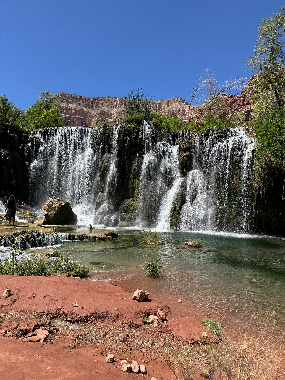
At mile 8.7 there is a cut off to the left that takes you to Fifty Foot Falls and Navajo Falls. It wasn't our intention to stop at the falls that day but we made it to that point in 5 hours so we had plenty of time to explore. It was a Saturday, so both falls were pretty crowded with locals so we only stayed for a little while at each. At about mile 10 is Havasu Falls, one of the reservations main attractions. Oh my gosh was it beautiful! 100-foot waterfall dropping into a blue green pool of water was an amazing sight, and the waterfall most people hiking there come to see. We saw it from the trail and then walked down to the bottom to have a rest and snack. The waterfall is right at the entrance to the campground, which is a mile long. At the beginning of he campground there is a spring that can be used for filling water bottles and bladders. Water taken from here does not need to be filtered. We filled all that we had and headed to find our campsite. Campsites are first come first serve and we wanted one along the creek, with a picnic table, and close to Mooney Falls, which is at the end of the campground. So we hiked about another mile and found the perfect site, one that met all of our criteria. We were a few campsites down from the bathrooms, which was handy too. The bathrooms were pretty clean our 4 days there, and toilet paper gets stocked each morning so some evenings they were out but we always brought our own. We set up our campground and rested again. All of the trails today were easy to follow and find. Our total time from the trailhead was 7.5 hours (We purposely took our time and a lot of pictures!) and our moving time was 5.5 hours.
I had found in my research (mostly from Facebook Havasupai groups but some internet searching) that there was a Havasupai gentleman that would deliver pizza on a bike to various spots around the reservation on Fridays and Saturdays. We found that he delivered to near the cafe so we decided that was our plan for dinner. We knew we could get cell service in the village so we hiked the 2 miles back up and called for a pizza. Unfortunately after waiting a half hour for a call back he informed us he was sold out. So plan B we ate at the cafe and it was basic but delicious. My brother ordered a strawberry lemonade and got the last of it; they were sold out for our remaining time there. We went to the market for ice cream and it was sold out. For a place that requires helicopters and mules to make their deliveries it is hard to plan. Be prepared for items in the village to be out of stock. We left the village and hiked the 2 miles to the campground, picked up our backpacks at the campground entrance, and went to sleep in our individual tents.
Day 1 Total Mileage: 16.97 Miles


Day 2: Mooney, Beaver Falls, and the Confluence
Our plan today was to go Mooney Falls, Beaver Falls, and the Confluence (where the Havasu Creek meets the Colorado River). We met a young woman across the creek from our campsite who was traveling alone. She had the same itinerary as us for the day so the 5 of us hiked together. We again dressed in layers and wore trail runners. Some people bring water shoes to change into at water crossings but we found that our trail runners with wool socks dried quickly so we all wore them and left the sandals at the campsite. We packed enough food and water for the day. Any water past the spring needs to be filtered so we carried all that we would need. We also bought toilet paper and bags (thankfully not needed!) as there are no bathrooms past the campground. Mooney Falls was less than .4 miles from our campsite and we headed out at 7:00 am to beat the crowds to the ladder and descent section to Mooney Falls. Some have reported waiting for an hour to get down, due to a long and slow line of hikers. This was the part that had me terrified, and rightfully so. It was daunting but I did it as I was determined to see all that was beyond that point. The climb down to the falls begins through 2 small wet caves. Then you have to climb down 200 feet using wet and slimy ladders, chains and steps carved into the cliff. It was helpful that I had my brother in front of me directing me where to put my hands and feet. We packed our own gloves (cheap gardening gloves from Walmart) but there were plenty there to use. Mooney falls is the highest of the Havasupai waterfalls at 200 feet tall and falls down a cliff into the beautiful waters below.


We headed out next to Beaver Falls, about 2 miles from Mooney Falls. It was in this section that the trail became harder to follow, as well as the beginning of the creek crossings. There were pink ribbons hung on some trees to help us follow the trail. We crossed the creek 3 times, none of them much above our knees, and had to climb down 2 ladders and do some rock scrambling, but it was worth it. Beaver Falls is about 50 feet tall and cascades into different pools. We only viewed the falls from the top and did not go down and swim in them, as is allowed. It is recommended to leave Beaver Falls by 10:00am to make it to the Confluence and back before evening. So we left the falls around 9:45 am and hiked back a little to where the trail split and there was a very faded sign directing us to the Confluence.


This hike required a lot of rock scrambling and moments of hoping we were on the right trail! It was difficult and dangerous at times in the beginning but leveled out and became a very pleasant hike. On our way we had 9 creek crossings. Most were waist high with very strong currents. We were glad we had our hiking poles for stability, and also to test how deep the water was in the direction we were going. The last 2 creek crossings were chest high and we had to hold our daypacks above our heads. The hike from Beaver to the Confluence was about 6 miles one way, and we got there around 12:30 pm. When we got to the point of the Havasu Creek joining the Confluence, we were expecting a drastic line where the blue green meets the brown of the river. But that was not the case on the day we went. It was all pretty much the same color and we were all a bit disappointed! We hung out on the rocks above the river for a bit and then headed back to the campground. We quickly made our way back and were at Mooney Falls at 4:45 pm. We saw a lot of Big Horned Sheep this day, on and beside all of the trails. There was even a family of them right on the trail walking ahead of us at one point. We made freeze dried chicken and mashed potatoes for dinner and after a long day they tasted pretty good! We walked to the spring and refilled all of our bottles and bladders for the next day. That evening we walked to the top of Mooney Falls and watched the stars come out. They were so vivid and vibrant.
Day 2 Total Mileage: 15.5 Miles


Day 3: Fry Bread, Swimming, Hidden Falls
After 2 strenuous days, we decided to relax a little on day 3. We got up and heard my brother say that a critter got into someone's daypack during the night. My sister forgot to take her snacks out from the day before and put them in her hanging rat sack with the rest of her food. What we assumed to be a squirrel unzipped her backpack, took out her bag of food, chewed it open, and ate her snacks, leaving the wrappers on the table. It also made off with a spoon that we never found. She quickly learned why hanging all food is a necessity! We ate breakfast and walked over to the top of Mooney Falls and hung out on the rocks a little. Then we headed into the village and got fry bread. Fry bread is a Native American dish similar to our funnel cake. We had heard that the fry bread stand near Havasu Falls is the best, but they hadn't been open on previous days so we got ours at the cafe. It was delicious and there were many toppings to choose from. We sectioned it and put caramel, chocolate, powdered sugar and cinnamon on each part of it. It is also serves as a base for chili, beans, and vegetables.


Dressed in our bathing suits and sandals we headed back up to the falls we saw the day we hiked in. We started at Fifty Foot Falls and we were the only ones there. We swam and hung out for a while and then went on to Navajo Falls. We stayed there for about 2 hours, and were alone most of the time. The water temperature is about 70 degrees so none of us stayed in the water long. But there was a little dirt area where we could lay down and chill. Then we found Hidden Falls. There is not a sign for it on the main trail but we found it due to directions I found on one of the FB pages. Before you get to Havasu Falls there is a little make shift shack with an awning. Turn left onto the trial in front of that and head down to the water. From there you take the trail until it ends, get in the water, and continue walking upstream until you see the falls. On our way to Havasu Falls we found the fry stand there to be open so we decided to try theirs and compare! These were a slightly different consistency and better than the ones at the cafe. They offered similar toppings and we sat at the picnic tables there and sampled different ones. After that we went to Havasu Falls and spent the rest of the day there. We headed back to the campground, filled our water bottles, and made freeze dried beef stew for dinner. We made it a habit to fill our water bottles or bladders every time we passed the spring. By doing this we never had to go out of our way for water, and we never had to filter water from the creek.
Day 3 Total Mileage: 6.73 Miles


Day 4: Hike Out + Trail Friend
Our backpacks had to be at the campground entrance by 6:00 am so we got up at 4:00 am, packed everything up, resupplied our water, and headed the 10 miles out. Again, we dressed in layers and wore our trail runners. We took our time again, knowing that our bags would not be at the top until between 10:00 am and noon.
In the village there are a lot of dogs running around. Some looked like they had owners, some were escorting the mule trains up the trail, and some were just hanging out. From the village we had the sweetest dog accompany us for 5 miles. She lead us, hung back with us, and stayed in line with us the whole 5 miles. She made sure we were on the right path if it split, and if one of us stopped to take a picture, she would stay with you until you met up with the group. Eventually a mule train came by and she was called to follow them so she left us and went on her way with the other animals. It was a really cool and unexpected experience! We took in the beauty for the last time and enjoyed every step we took. We marveled at the canyon walls and colors, and talked about the wonderful feeling of being so remote. Overall I did not find this to be too strenuous of a hike. The last 2 miles of switchbacks were a little challenging, but we were fortunate not to have a strong sun on us, and we went slow and took a lot of breaks. It took us 6.25 hours to reach the top (5.25 hours moving time). And as we learned throughout this trip Havasupai time runs a little slower than ours and our bags arrived at the trailhead at 2:00pm! But we used that time to talk to others either starting or ending their hikes, and some locals. And we soaked up the beauty one last time!
Day 4 Total Mileage: 10.85 Miles


Gear and Packing List
My Packing List:
Sleeping Bag
Sleeping Liner
Tarp/Ground cover
Tent
Sleeping Pad
40 L Backpack
Camp Chair
Hiking Poles
Water Reservoir
Water Bottle
Filter (Never Used)
First Aid Kit
Jet Boil-1 was enough for 4 people
Fuel
Rodent Safe Bags
Utensils
Hammock
Utility Cord for hanging food and wet clothing
Quick dry towel
Headlamp
Day Pack
Gloves for Mooney Falls
Toilet Paper
Body Wipes
Satellite Phone
Cell phones with downloaded maps
Portable charger
Cash
Toiletries
ID
Plastic bag for trash, dirty/wet clothes
Trail Runners
Water shoes/sandals
3 short sleeve shirts- I would have packed less clothing if we didn't have the mule
3 shorts
1 pants
2 long sleeve shirts
5 Wool socks
4 Underwear
1 Bathing suit
2 Sports bras
1 Sleep shirt
1 Sleep/lounge pants
3 Mountain House Meals-Only needed 2 but didn't want to depend on cafe or pizza
4 Aloha bars
2 RipVan Waffles
4 ProMeal bars
4 Gels/Bloks
Cashews
Almonds
Peanut M&Ms
2 Peanut Butter Crackers
2 Belvita Bars
2 Granola bars
Salt Tablets


Final Thoughts & Highlights
How fortunate we were to have had this opportunity to visit these tribal lands. It was truly one of the most beautiful places I've seen. Although we had to wait years to get here it was totally worth it. I will never forget walking on the trail and coming up to Havasu Falls, seeing and hearing the thundering falls pouring off the rocks into the prettiest water I have ever seen. I had seen so many pictures but nothing prepared me for the awe that I felt when we came upon that waterfall. We were all silent for a minute, unable to voice what we were seeing. The hike down to that point was great, as were the other waterfalls, but I think we all felt this was the spot our adventure truly began.
I highly recommend this 4 day trek to anyone considering it, even if you're not an avid hiker or camper. It takes a little planning and research and we found April was the perfect time to visit. The temperatures were great, and the bugs, snakes and scorpions were not out yet! And it is typically not the rainy season. We were tested physically with the long hikes and mentally with the climbing down to Mooney Falls and other sketchy parts of the trails, but I wouldn't have done anything differently. Being on these lands, meeting the locals, camping with strangers that quickly became friends, and seeing the natural beauty is something I will be talking about for years!
Thanks for reading, and remember, there's always more to be explored!
-Christine & Nicole


Comments